


 3:21 AM
 Ronson

ASSIGNMENT ON
GEOMORPHOLOGY
FLUVIAL LANDFORMS PROCESSES
LALTANPUIA
ROLL NO – 22
M.SC
DEPT. OF GEOGRAPHY & RM
MEANING OF FLUVIAL:
The adjective ‘fluvial’ (from Latin fluvius, river) refers, in geomorphology, to the work of rivers but in the context of landform development and it includes the work of both overland flow and stream flow. Thus landforms shaped by running water, which is by the fluvial processes, are called fluvial landforms. Fluvial landforms and processes dominate the continental land surface or we can say that running waters are the most active geomorphic agency.
Landforms made by others agencies such as Glacial or Wind (Aeolian processes) action occupies relatively small areas of the continental surfaces. The fluvial landforms constitute by far the largest proportion of the environment of terrestrial life and the major areas of food production, almost all the land has been shaped by fluvial processes. As we all know there is a continuous movement of water from the oceans to the atmosphere, from the atmosphere to the land, and from the land back again to the sea. This endless circulation of water is termed as the hydrological cycle or water cycle
OVERLAND FLOW AND STREAMFLOW:
Overland Flow: When rain water falling on the surface, it is removed by infiltration into the soil or rock by sheet flow over the surface. Overland flow is the term used for the movement of water over the surface of the land when it is not confined to distinctive channels. Overland flow is responsible for much erosion before streams attain identity lower down the slope, soil particles are loosened up by the rain impact, this is called splash erosion.
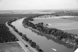
Stream flow: The gully system develops into a full-fledged drainage pattern as it undergoes systematic changes .There is rapid increase in tributaries by the growth of flowing water down the side of the slopes of widening gullies. The total length of stream channels rapidly increases by elongation at the heads where the erosion is carried on by rain itself. It enables head ward erosion to cut back into the slope above the point at which the head stream starts its career, this movement is called stream flow.
FLUVIAL PROCESSES OR THE WORKS OF RIVERS
The river does three kinds of work – erosion, transportation and deposition. It cuts its side and beds, this is erosion. Its moves the materials cut by its own erosive power as well as those received from rain wash; this is called transportation. Then where the flow of river water slackens or slow down, the sand, silt and rock fragments get deposited; this is deposition. These different kinds of activity are not quite independent of one another but are interdependent. Through the joint action of these activities the river degrades the surface of the land, carves its own valley, creates flood plains and deltas and leaves the area of relatively harder rocks as residual hills and plateaus. From the point of view of landscape evolution, the erosion performed by the river is the most important, but there is such a close relationship between erosion and transportation that these activities cannot be understood independently of each other.
LANDFORMS DUE TO FLUVIAL PROCESSES:
We may divide the landforms built by river action into two major categories-erosional and depositional landforms.
1. EROSIONAL LANDFORMS:
The erosion performed by rivers is of two kinds-chemical and mechanical. Some of the rocks over which the river flows, such as limestone, are soluble and the river dissolves the rocks along the joints and forms cavities in them. This is chemical erosion. Chemical erosion is performed through solution. But the mechanical erosion performed by a river is far more important than chemical erosion as it is largely through mechanical erosion that the river derives it debris or load. Apart from solution, the erosive work of a river consists of three interacting processes-hydraulic action, corrasion and attrition.
(i) Gorge or Canyon:
A canyon or gorge is a deep ravine between cliffs often carved from the landscape by a river. Rivers have a natural tendency to reach a baseline elevation, which is the same elevation as the body of water it will eventually drain into. It is deep valley with steep walls formed by river in hilly area, Its bank continues rising while its bed is deepened due to down cutting of a river

(ii) V-shaped valley:
` An elongated lowland between ranges of mountains, hills, or other uplands, often having a river or stream running along the bottom is called V-shaped valley. They are usually found near the source of a river due to the presence of a steeper gradient. However, they can also be formed downstream when there is a fall in sea level or a rise in land level.

(iii) Waterfalls & Rapid:
Waterfalls occur where there is a significant step or drop in the river bed so the water flows over and falls over this drop. Waterfalls are generally found in the upper course of the river.
Rapids are stretches in a river where the water is turbulent due to underlying rock which has been eroded away in places at different rates, creating an uneven riverbed. They are usually occur in the upper coarse of the river where the load particle size is larger.
(iv) Pot-holes:
Cylindrical pit formed in the rocky channel of a turbulent stream. It is formed and enlarged by the circular water currents that move against the main current of a stream. Potholes are most commonly found at the bottoms of eddies in rivers and in plunge pools below cataracts; sometimes potholes in a rock outcrop indicate the former site of a rapid or cataract.

(v) River Terraces:
It is bench or step that extends along the side of a valley and represents a former level of the valley floor. It generally has a flat top made up of sedimentary deposits and a steep fore edge, and it may be the remains of an old floodplain, cut through by the river and left standing above the present floodplain level. Another type of terrace is cut into bedrock and may have a thin veneer of alluvium, or sedimentary deposits. In paired terraces, the terrace features on each side of a valley correspond.

2. DEPOSITIONAL LANDFORMS:
As the velocity of a river decreases, it begins depositing its load of rock fragments, sand and silt, since its capacity to transport these materials is dependent upon its velocity. When a fast flowing hill stream emerges from the mountains and reaches a relatively level surface, there is a deposition of a huge amount of stony debris, sand and silt, alluvial fans and cones are formed here.
Important landforms produced by the depositional works of a river are:
(i) Alluvial Fans or cones:
This is A fan-shaped accumulation of alluvium deposited at the mouth of a gorge or at the sides of a tributary stream with the main stream or in short a fan-shaped mass of alluvium deposited as the flow of a river decreases in velocity.
(ii) Natural Levees:
` Natural Levees are a long, broad, low ridge built by a stream on its flood plain along one or both banks of its channel in time of flood, a deposit of sand or mud built up along, and sloping away from, either side of the flood plain of a river or stream.
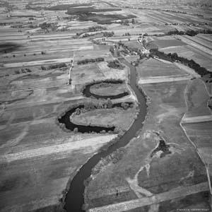
(iii) Ox-Bow Lakes:
An oxbow lake is essentially a curved lake formed at a former oxbow where the main stream of the river has cut across the narrow end and no longer flows around the loop of the bend.
As the outer banks of a meander continue to be eroded, the neck of the meander becomes narrow and narrower. Eventually due to the narrowing of the neck, the two outer bends meet and the river cuts through the neck of the meander usually during a flood event when the energy in the river is at its highest. The water now takes its shortest route rather than flowing around the bend and finally formed Ox Bow lake.

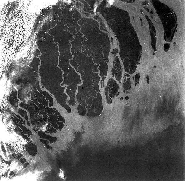
(iv) Delta:
Deltas are formed from the deposition of the sediment carried by the river as the flow leaves the mouth of the river. Over long periods of time, this deposition builds the characteristic geographic pattern of a river delta. River deltas form when a river carrying sediment reaches either a body of standing water, such as a lake, ocean, or reservoir, another river that cannot remove the sediment quickly enough to stop delta formation, or an inland region where the water spreads out and deposits sediments
In addition, all these depositional features are of great significance, as they provide fertile land for cultivation and from the earliest times have provided the most attractive sites for human settlements.
References:
Thornbury, W.D., (1990) : Principles of Geomorphology, J.Wiley, New York
Dayal, P. (1996) : A Text Book of Geomorphology, Shukla Book Depot, Patna.
Singh, Savindra, (1998) : Geomorphology, Prayag Pustak Bhawan, Allahabad.


0 comments:
Post a Comment